"Power lines along road" This is actually looking over a field at the new rock wall; Burke Mountain in the distance. The road is today's Lougheed Highway in front of Riverview Hospital, the wall was removed when the highway was widened. Ca.1911-1919
"Power lines along road 2" same as above
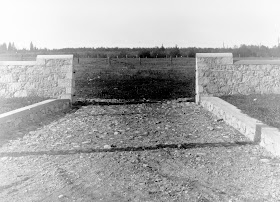
"Stone gates" Misnomer there :) ca.1911-1919. See below for a latter view
The Administration building. ca.1925; CVA 371-313
Note the wall on the left, now widened to accommodate the steps leading up past a water feature on the way to the Administration building. Sadly all of this was destroyed when the Lougheed Highway was widened, and when Valleyview 300 was built. View this Google Streetview Image, to see how it appears today from almost the same vantage point.
Note the wall on the left, now widened to accommodate the steps leading up past a water feature on the way to the Administration building. Sadly all of this was destroyed when the Lougheed Highway was widened, and when Valleyview 300 was built. View this Google Streetview Image, to see how it appears today from almost the same vantage point.
"Stone fence and power lines along road" Now this is looking straight along the rock wall, Coquitlam Mountain way off in the distance. Today, Lougheed Highway is where this wall was.
Notice way off at the end of the field that there is two buildings one appears to be a church ! this is in the same location as the Power distribution building. Interesting that this was beside today's cemetery
The building to the left of it, is in the exact location of today's Ambulance Station, which was at one time the home of a BISCO official, the stated date for that home is 1923, but this photo must be before 1920, because BISCO was built in 1920. Makes me wonder if this home is earlier in date than stated, maybe it was the home of the resident theologian.?
"Fence and river" Notice the bridge on the left; it was never known until this image appeared that there was a bridge here at one time, probably lost in the 1921 flood, and never replaced. The Coquitlam River, today has been straightened out through here, the area with the river in it on the right is today land, and the river roughly parallels the wall. The future Lougheed Highway is of course just over the wall.


